MagicMtnDan
FRF Addict
For those who are interested in Anza-Borrego Desert State Park and Ocotillo Wells, I thought I'd bring together links that could be useful:
Thread:
http://www.fordraptorforum.com/f112...za-borrego-desert-state-park-7499/#post538768
We've all read about the Raptor SVT test route that Ford set up for their testing and the early runs they gave to the editors of the magazines and online journals:
Above from: 2010 Ford F-150 SVT Raptor: First Drive
Above from: Ride Impression Ford F-150 SVT Raptor: Off-Road.com
We knew Ford tested the Raptors in Anza-Borrego Desert State Park but it's a big place. Until tonight, when I found the following references to the test route, I never knew quite where Ford tested and ran the Raptors. We've been to Anza-Borrego Desert State Park numerous times and I've always suspected that we've driven on some/all of the trails and areas they ran on but I wasn't sure. Now I know we've been on them without realizing it.
So, here's the route:

Link to the above map and article:
2010 Ford F-150 SVT Raptor: First Drive
Link to a map of the above area with some pics:
Panoramio - Photos of the World
Now I need to compare the above maps to the maps of the area:
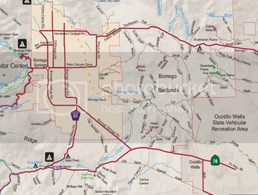
Link to Anza-Borrego Desert State Park map (pdf):
http://www.parks.ca.gov/pages/638/files/ABDSPmap.pdf
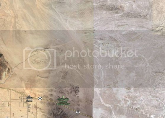
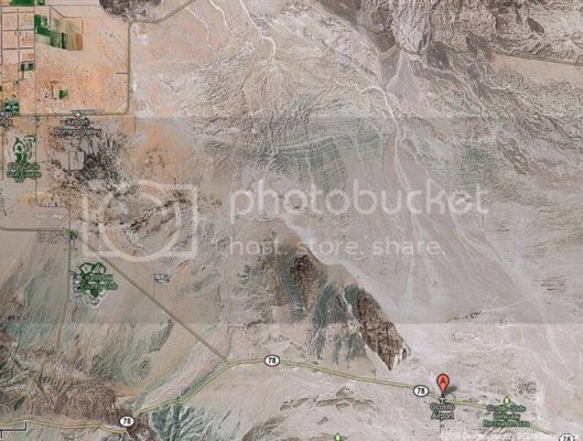
Google map of the area:
http://maps.google.com/maps?rlz=1T4...o+springs+map&um=1&ie=UTF-8&sa=N&hl=en&tab=wl
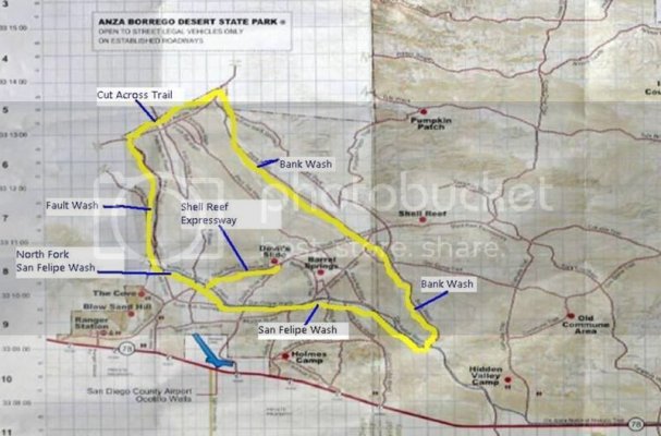
OK, here's one possiblity where the route is in Anza-Borrego Desert State Park and in Ocotillo Wells SVRA. Perhaps Brian and/or others can compare this to the above info.
We'll have to drive this route and see what the distance is. It's a tough job but someone's got to do it.
Ocotillo Wells
Thread link:
http://www.fordraptorforum.com/f114/ocotillo-wells-state-vehicular-recreation-area-svra-19520/
Thought I'd share this "data sheet" on Ocotillo Wells I've put together so others can use this basic information and links...
Ocotillo Wells State Vehicular Recreation Area (SVRA)
5172 Highway 78
Borrego Springs, CA
District Office: (760) 767-5391
Ranger Station: (760) 767-5391
Pioneer's Memorial Hospital: (760) 344-2120
Emergency: 911
More than 80,000 acres of magnificent desert are open for off-highway exploration and recreation within the boundaries portrayed on the park map are operated by California State Parks. Outside the boundaries, to the south and east, large tracts of BLM land (U.S. Department of the Interior, Bureau of Land Management) are also open to off-highway vehicles. The western boundary and part of the northern boundary connect with the half-million acre Anza-Borrego Desert State Park, which is closed to off-highway recreation, but open to exploration by highway-legal vehicles along established primitive roads.
The rangers and staff of Ocotillo Wells are dedicated to providing a safe and enjoyable desert riding environment, and to ensuring that a quality experience remains available for future generations.
No fees are collected for camping or day use. Open camping is permitted throughout the unit for up to 30 days per calendar year. Vault toilets, shade ramadas, picnic tables, and fire rings are located in the Quarry, Main Street, and Holmes Camp areas. Water is not available. Vehicle repair shops, fuel, telephones, groceries, a motel and restaurants are available in the neighboring small town of Ocotillo Wells and along Highway 78 where it borders the park.
Camping:
Ocotillo Wells is open seven days a week, 24 hours a day. Open camping is available throughout the park for up to 30 days per calendar year. Camping is not permitted at the Shell Reef, Devils Slide, and Blow Sand Hill areas. If you are in a self-contained vehicle with holding tanks, fill your tanks before you arrive—water filling stations are not available.
Links:
Ocotillo Wells State Vehicular Recreation Area (SVRA) – State Web site: Ocotillo Wells SVRA
Blow Sand
Ocotillo Wells GPS Map for Garmin Receivers
Maps!
1. Map of the area:
http://ohv.parks.ca.gov/pages/1170/files/OcotilloMap_WEB.pdf
2. Blow Sand dot com map:
Ocotillo Wells SVRA Map
3. GPS map for Garmin receivers:
Anza-Borrego Explorer - A GPS Map for Garmin Receivers
Anza-Borrego Explorer - Ocotillo Wells State Vehicular Recreation Area
4. Topo map
Ocotillo Wells State Vehicular Recreation Area Topo Map
---------- Post added at 08:20 AM ---------- Previous post was at 08:15 AM ----------
OW trail map
http://www.anzaborregoexplorer.com/MapCoverage/images/OcotilloWellsMap-Wide.JPG
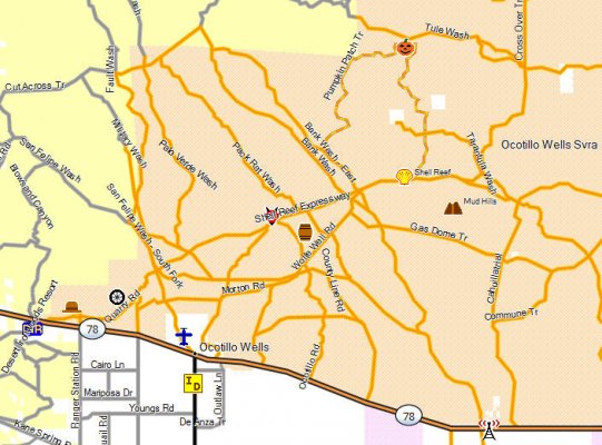
A-B DSP & Ocotillo Wells run
Thread: http://www.fordraptorforum.com/f112...orrego-desert-state-park-ocotillo-wells-8388/
Thread link:
http://www.fordraptorforum.com/f113/raptor-run-saturday-april-16th-abdsp-ocotillo-wells-svra-8365/
Raptor Run - April 2011
When: Saturday and Sunday, April 16 & 17
Where: Meet Saturday morning at Anza-Borrego Desert State Park Visitor Center parking lot
Visitor Center address for your GPS: 200 Palm Canyon Drive, Borrego Springs CA 92004
Time: 9:00AM Saturday morning (9:30 departure)
Camping: We'll be camping Saturday night at Borrego Palm Campground (very close to Visitor Center) if space(s) are available or at Tamarisk Grove Campground (at intersection of S3 and 78) if space(s) are available or, if none are available, we'll find a spot in the desert for some "primitive camping" (if you’re camping please bring firewood).
Weather: It will be great...94 Saturday, 65 Saturday night; 91 on Sunday (bring lots of water/ice & sunscreen). It’s a dry heat.
Bring lunch, chairs and shade for lunch on the trail.
RSVP: if you can, let me know if you’re coming. If you’re running late on Saturday, call me and let me know (email or PM me for my phone number) and, depending on when you’ll be there we can wait.
Links:
Google map of the area: http://www.parks.ca.gov/lat_long_map/default.asp?lvl_id=278
A-B DSP park map: http://www.parks.ca.gov/pages/638/files/ABDSPmap.pdf
http://www.parks.ca.gov/pages/638/files/AnzaBorregoDesertPDF.pdf
Map showing 6 major sections of A-BDSP: http://www.borregospringschamber.com/abdsp/map2.htm
General park map: http://www.borregospringschamber.com/abdsp/map1.htm
Detailed park map showing major trails & washes: http://www.parks.ca.gov/pages/638/files/ABDSPmap.pdf
Anza-Borrego Desert State Park – State Web site: http://www.parks.ca.gov/?page_id=638
Anza-Borrego Desert State Park org site: http://www.abdsp.org/
A-B DSP Palm Canyon campground:
http://www.parks.ca.gov/pages/638/files/AnzaBorregoDesertPDF.pdf
Tamarisk Grove Campground:
http://www.campsitephotos.com/campground/Tamarisk-Grove
ABDSP Weather:
http://www.weather.com/outlook/recreation/outdoors/weekend/CASPANZABO:13
Web site for making camp site reservations (Reserve America): http://www.reserveamerica.com/campgroundDetails.do?subTabIndex=0&contractCode=ca&parkCode=anza
A-B DSP
Thread link:
http://www.fordraptorforum.com/f114/anza-borrego-desert-state-park-b-dsp-5477/
Anza-Borrego Desert State Park is the largest state park in California. Five-hundred miles of dirt roads, 12 wilderness areas and miles of hiking trails provide visitors with an unparalleled opportunity to experience the wonders of the California Desert.
The park is named after Spanish explorer Juan Bautista de Anza and the Spanish name borrego, or bighorn sheep. The park features washes, wildflowers, palm groves, cacti and sweeping vistas. Visitors may also have the chance to see roadrunner, golden eagles, kit foxes, mule deer and bighorn sheep as well as iguanas, chuckwallas and the red diamond rattlesnake.
Anza-Borrego Desert State Park
200 Palm Canyon Drive
Borrego Springs CA 92004-5005
Visitor Center: 760-767-4205
Park Headquarters: 760-767-5311
Anza-Borrego Desert State Park® is located on the eastern side of San Diego County, with portions extending east into Imperial County and north into Riverside County.
Many visitors approach from the east or west via Highways S22 and 78. From the coast, these highways descend from the heights of the Peninsular range of mountains with spectacular views of the great bowl of the Colorado Desert. Highway S2 enters the park from the south off of Interstate 8.
Visitor Center - Hours & Days:
9:00am to 5:00pm
Open Thursday - Monday October through May
Closed Tuesday & Wednesday
Open weekends only June through September
Links:
Anza-Borrego Desert State Park – State Web site: Anza-Borrego Desert SP
Anza-Borrego Desert State Park org site: Anza Borrego Desert State Park
Web site for making camp site reservations (Reserve America): ANZA-BORREGO DESERT SP, CA - Campground & Camping Details - ReserveAmerica - [ca]
Maps!
1. Google map of the area: http://www.parks.ca.gov/lat_long_map/default.asp?lvl_id=278
2. Detailed park map showing major trails & washes: http://www.parks.ca.gov/pages/638/files/ABDSPmap.pdf
3. Palm Canyon Campground map showing campsites: http://www.parks.ca.gov/pages/638/files/AnzaBorregoDesertPDF.pdf
4. General park map: Maps
5. Map showing 6 major sections of A-BDSP: Maps
---------- Post added at 03:53 PM ---------- Previous post was at 03:52 PM ----------
Another Raptor Run:
http://www.fordraptorforum.com/f112...rego-dsp-ocotillo-wells-11-26-27-2010-a-7635/
Thread:
http://www.fordraptorforum.com/f112...za-borrego-desert-state-park-7499/#post538768
We've all read about the Raptor SVT test route that Ford set up for their testing and the early runs they gave to the editors of the magazines and online journals:
Ford's PR team carefully planned a jump free route for us to avoid the liability of inadvertently jostling the pacemakers of geriatric buff book hacks, but we managed to channel our inner hoon and find a good ramp regardless. We hit the four-foot high berm at 80 MPH and caught what felt like serious air, but even that failed to overcome the natural stability and the Raptor's ability to soak up anything thrown at it. It landed perfectly and carried on as if nothing had happened. Even sliding sideways into ruts and bumps near the limited top speed failed to provoke any roll or any sign at all that we could do anything to upset the Raptor.
Above from: 2010 Ford F-150 SVT Raptor: First Drive
The next morning we woke up early to head out to the desert for what we came for – off-road testing of the Raptor. While developing the Raptor, the SVT testing team (consisting largely of the engineers that helped build the vehicle) set up a roughly 66-mile course to punish each Raptor prototype. Every time they reached a new stage and another prototype vehicle was created, it had to survive 1000 miles on the 66-mile off-road course filled with whoops, sand washes, off-camber turns and constantly changing terrain. Fortunately for the journalists in attendance, we had the chance to charge around 22 miles of this course to test out the Raptor.
Above from: Ride Impression Ford F-150 SVT Raptor: Off-Road.com
We knew Ford tested the Raptors in Anza-Borrego Desert State Park but it's a big place. Until tonight, when I found the following references to the test route, I never knew quite where Ford tested and ran the Raptors. We've been to Anza-Borrego Desert State Park numerous times and I've always suspected that we've driven on some/all of the trails and areas they ran on but I wasn't sure. Now I know we've been on them without realizing it.
So, here's the route:

Link to the above map and article:
2010 Ford F-150 SVT Raptor: First Drive
Link to a map of the above area with some pics:
Panoramio - Photos of the World
Now I need to compare the above maps to the maps of the area:

Link to Anza-Borrego Desert State Park map (pdf):
http://www.parks.ca.gov/pages/638/files/ABDSPmap.pdf


Google map of the area:
http://maps.google.com/maps?rlz=1T4...o+springs+map&um=1&ie=UTF-8&sa=N&hl=en&tab=wl
OK, here's one possiblity where the route is in Anza-Borrego Desert State Park and in Ocotillo Wells SVRA. Perhaps Brian and/or others can compare this to the above info.
We'll have to drive this route and see what the distance is. It's a tough job but someone's got to do it.

Ocotillo Wells
Thread link:
http://www.fordraptorforum.com/f114/ocotillo-wells-state-vehicular-recreation-area-svra-19520/
Thought I'd share this "data sheet" on Ocotillo Wells I've put together so others can use this basic information and links...
Ocotillo Wells State Vehicular Recreation Area (SVRA)
5172 Highway 78
Borrego Springs, CA
District Office: (760) 767-5391
Ranger Station: (760) 767-5391
Pioneer's Memorial Hospital: (760) 344-2120
Emergency: 911
More than 80,000 acres of magnificent desert are open for off-highway exploration and recreation within the boundaries portrayed on the park map are operated by California State Parks. Outside the boundaries, to the south and east, large tracts of BLM land (U.S. Department of the Interior, Bureau of Land Management) are also open to off-highway vehicles. The western boundary and part of the northern boundary connect with the half-million acre Anza-Borrego Desert State Park, which is closed to off-highway recreation, but open to exploration by highway-legal vehicles along established primitive roads.
The rangers and staff of Ocotillo Wells are dedicated to providing a safe and enjoyable desert riding environment, and to ensuring that a quality experience remains available for future generations.
No fees are collected for camping or day use. Open camping is permitted throughout the unit for up to 30 days per calendar year. Vault toilets, shade ramadas, picnic tables, and fire rings are located in the Quarry, Main Street, and Holmes Camp areas. Water is not available. Vehicle repair shops, fuel, telephones, groceries, a motel and restaurants are available in the neighboring small town of Ocotillo Wells and along Highway 78 where it borders the park.
Camping:
Ocotillo Wells is open seven days a week, 24 hours a day. Open camping is available throughout the park for up to 30 days per calendar year. Camping is not permitted at the Shell Reef, Devils Slide, and Blow Sand Hill areas. If you are in a self-contained vehicle with holding tanks, fill your tanks before you arrive—water filling stations are not available.
Links:
Ocotillo Wells State Vehicular Recreation Area (SVRA) – State Web site: Ocotillo Wells SVRA
Blow Sand
Ocotillo Wells GPS Map for Garmin Receivers
Maps!
1. Map of the area:
http://ohv.parks.ca.gov/pages/1170/files/OcotilloMap_WEB.pdf
2. Blow Sand dot com map:
Ocotillo Wells SVRA Map
3. GPS map for Garmin receivers:
Anza-Borrego Explorer - A GPS Map for Garmin Receivers
Anza-Borrego Explorer - Ocotillo Wells State Vehicular Recreation Area
4. Topo map
Ocotillo Wells State Vehicular Recreation Area Topo Map
---------- Post added at 08:20 AM ---------- Previous post was at 08:15 AM ----------
OW trail map
http://www.anzaborregoexplorer.com/MapCoverage/images/OcotilloWellsMap-Wide.JPG

A-B DSP & Ocotillo Wells run
Thread: http://www.fordraptorforum.com/f112...orrego-desert-state-park-ocotillo-wells-8388/
Thread link:
http://www.fordraptorforum.com/f113/raptor-run-saturday-april-16th-abdsp-ocotillo-wells-svra-8365/
Raptor Run - April 2011
When: Saturday and Sunday, April 16 & 17
Where: Meet Saturday morning at Anza-Borrego Desert State Park Visitor Center parking lot
Visitor Center address for your GPS: 200 Palm Canyon Drive, Borrego Springs CA 92004
Time: 9:00AM Saturday morning (9:30 departure)
Camping: We'll be camping Saturday night at Borrego Palm Campground (very close to Visitor Center) if space(s) are available or at Tamarisk Grove Campground (at intersection of S3 and 78) if space(s) are available or, if none are available, we'll find a spot in the desert for some "primitive camping" (if you’re camping please bring firewood).
Weather: It will be great...94 Saturday, 65 Saturday night; 91 on Sunday (bring lots of water/ice & sunscreen). It’s a dry heat.
Bring lunch, chairs and shade for lunch on the trail.
RSVP: if you can, let me know if you’re coming. If you’re running late on Saturday, call me and let me know (email or PM me for my phone number) and, depending on when you’ll be there we can wait.
Links:
Google map of the area: http://www.parks.ca.gov/lat_long_map/default.asp?lvl_id=278
A-B DSP park map: http://www.parks.ca.gov/pages/638/files/ABDSPmap.pdf
http://www.parks.ca.gov/pages/638/files/AnzaBorregoDesertPDF.pdf
Map showing 6 major sections of A-BDSP: http://www.borregospringschamber.com/abdsp/map2.htm
General park map: http://www.borregospringschamber.com/abdsp/map1.htm
Detailed park map showing major trails & washes: http://www.parks.ca.gov/pages/638/files/ABDSPmap.pdf
Anza-Borrego Desert State Park – State Web site: http://www.parks.ca.gov/?page_id=638
Anza-Borrego Desert State Park org site: http://www.abdsp.org/
A-B DSP Palm Canyon campground:
http://www.parks.ca.gov/pages/638/files/AnzaBorregoDesertPDF.pdf
Tamarisk Grove Campground:
http://www.campsitephotos.com/campground/Tamarisk-Grove
ABDSP Weather:
http://www.weather.com/outlook/recreation/outdoors/weekend/CASPANZABO:13
Web site for making camp site reservations (Reserve America): http://www.reserveamerica.com/campgroundDetails.do?subTabIndex=0&contractCode=ca&parkCode=anza
A-B DSP
Thread link:
http://www.fordraptorforum.com/f114/anza-borrego-desert-state-park-b-dsp-5477/
Anza-Borrego Desert State Park is the largest state park in California. Five-hundred miles of dirt roads, 12 wilderness areas and miles of hiking trails provide visitors with an unparalleled opportunity to experience the wonders of the California Desert.
The park is named after Spanish explorer Juan Bautista de Anza and the Spanish name borrego, or bighorn sheep. The park features washes, wildflowers, palm groves, cacti and sweeping vistas. Visitors may also have the chance to see roadrunner, golden eagles, kit foxes, mule deer and bighorn sheep as well as iguanas, chuckwallas and the red diamond rattlesnake.
Anza-Borrego Desert State Park
200 Palm Canyon Drive
Borrego Springs CA 92004-5005
Visitor Center: 760-767-4205
Park Headquarters: 760-767-5311
Anza-Borrego Desert State Park® is located on the eastern side of San Diego County, with portions extending east into Imperial County and north into Riverside County.
Many visitors approach from the east or west via Highways S22 and 78. From the coast, these highways descend from the heights of the Peninsular range of mountains with spectacular views of the great bowl of the Colorado Desert. Highway S2 enters the park from the south off of Interstate 8.
Visitor Center - Hours & Days:
9:00am to 5:00pm
Open Thursday - Monday October through May
Closed Tuesday & Wednesday
Open weekends only June through September
Links:
Anza-Borrego Desert State Park – State Web site: Anza-Borrego Desert SP
Anza-Borrego Desert State Park org site: Anza Borrego Desert State Park
Web site for making camp site reservations (Reserve America): ANZA-BORREGO DESERT SP, CA - Campground & Camping Details - ReserveAmerica - [ca]
Maps!
1. Google map of the area: http://www.parks.ca.gov/lat_long_map/default.asp?lvl_id=278
2. Detailed park map showing major trails & washes: http://www.parks.ca.gov/pages/638/files/ABDSPmap.pdf
3. Palm Canyon Campground map showing campsites: http://www.parks.ca.gov/pages/638/files/AnzaBorregoDesertPDF.pdf
4. General park map: Maps
5. Map showing 6 major sections of A-BDSP: Maps
---------- Post added at 03:53 PM ---------- Previous post was at 03:52 PM ----------
Another Raptor Run:
http://www.fordraptorforum.com/f112...rego-dsp-ocotillo-wells-11-26-27-2010-a-7635/


